|
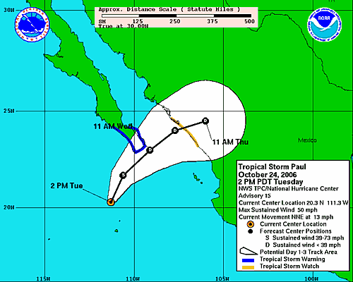
TROPICAL STORM PAUL ADVISORY NUMBER 15
NWS TPC/NATIONAL HURRICANE CENTER MIAMI FL EP172006
200 PM PDT TUE OCT 24 2006
Paul Continues to Weaken
A tropical storm warning is in effect for Baja California from Agua Blanca southward on the west coast and from La Paz southward on the east coast. A tropical storm warning means that tropical storm conditions are expected within the warning area within the next 24 hours.
A tropical storm watch is in effect for the west coast of mainland Mexico from Mazatlan to Altata. a tropical storm watch means that tropical storm conditions are possible within the watch area, generally within 36 hours.
Some of the watches and/or warnings could be discontinued later today.
For storm information specific to your area, including possible inland watches and warnings, please monitor products issued by your local weather office.
At 200 pm pdt...2100z...the center of Tropical Storm Paul was located near latitude 20.3 north, longitude 111.3 west or about 200 miles (325 km) south-southwest of Cabo San Lucas, Mexico and about 375 miles (600 km) west-southwest of Mazatlan, Mexico.
Paul is moving toward the north-northeast near 13 mph (20 km/hr) and a gradual turn toward the northeast is expected during the next 24 hours.
Maximum sustained winds have decreased to near 50 mph (85 km/hr) with higher gusts. Additional weakening is forecast during the next 24 hours.
Tropical Storm force winds extend outward up to 90 miles (150 km) from the center.
Estimated minimum central pressure is 999 mb (29.50 inches).
Paul is expected to produce total rainfall accumulations of 1 to 3 inches over the extreme southern tip of Baja California, south of La Paz. Paul is also expected to produce 3 to 5 inches of rain over the west-central coast of Mexico from Teacapan to Mazatlan and Culiacan, with possible isolated maximum amounts of 8 to 10 inches over the higher elevations of the Sierra Madre Occidentals.
An intermediate advisory will be issued by the National Hurricane Center at 500 pm pdt followed by the next complete advisory at 800 pm pdt.
Forecaster: Rhome/Pasch
__________
The current projected path now suggest that Tropipcal Storm Paul will pass close to Los Cabos sometime Wednesday late morning to early evening. It looks like Paul will be weakening and may be a Tropical Depression when it nears Los Cabos, but could bring high winds and heavy rains. Tropical storm preparations should be underway. The rain and stopped, cloudy conditions and there are light winds in the Los area. Heavy rain was reported earlier this morning.
|