|
HURRICANE PAUL INTERMEDIATE ADVISORY NUMBER 10A
NWS TPC/NATIONAL HURRICANE CENTER MIAMI FL EP172006
1100 AM PDT MON OCT 23 2006
Paul is moving slowly northward with little change in strength.
A hurricane watch remains in effect for the southern Baja California Peninsula from Agua Blanca southward on the west coast and from La Paz southward on the east coast. A hurricane watch means that hurricane conditions are possible within the watch area, generally within 36 hours. Additional watches or warnings may be required later today or tonight.
For storm information specific to your area, including possible inland watches and warnings, please monitor products issued by your local weather office.
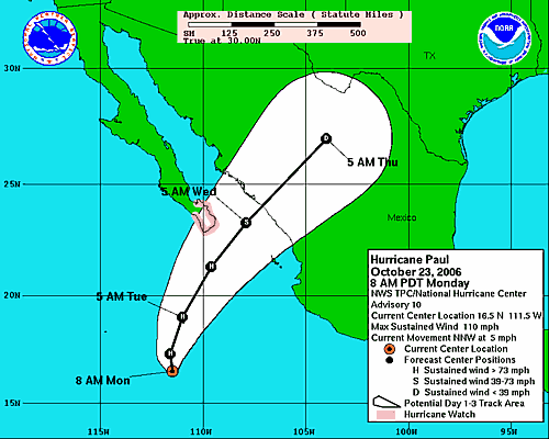
At 1100 am pdt...1800z...the center of Hurricane Paul was located near latitude 16.7 north, longitude 111.5 west or about 440 miles (710 km) south-southwest of Cabo San Lucas, Mexico.
Paul is moving toward the north at about 5 mph (7 km/hr) and some increase in forward speed is expected during the next 24 hours.
Maximum sustained winds are near 105 mph (165 km/hr) with higher gusts. Little change in strength is likely through tonight. A US Air Force reserve unit hurricane hunter plane is currently approaching the eye of the hurricane.
Hurricane force winds extend outward up to 25 miles(35 km) from the center and tropical storm force winds extend outward up to 100 miles (155 km).
Estimated minimum central pressure is 970 mb (28.64 inches).
The next advisory will be issued by the national hurricane center at 200 pm pdt.
Forecaster Pasch
The current projected path will bring Hurricane Paul near Los Cabos sometime Tuesday afternoon or Wednesday morning. It looks like Paul could miss the Los Cabos area with its full force, but could still bring high winds and heavy rains. Hurricane precautions and tropical storm preparations should be underway.
|